Backpacking the Enchanted Valley & South Coast
After I had spent two days in Seattle, I headed out to Olympic National Park. To be honest, it was difficult for me to enjoy Seattle. It might have been travel fatigue but I will say that I found the scenery around the city quite impressive. However, the city itself did nothing for me. Anyway... onto the crown jewel of this post: Olympic National Park!
May 19th, 2017
Graves Creek Trailhead to O'Neil Creek Camp - 6.5 miles
Olympic is quite stunning in the simple fact that it boasts three distinct regions all within the park boundary (and out). The high alpine region, the rain forests, and the rugged-yet-picturesque coastline. I spent most of the first day driving out to the Park, obtaining my permit and bear canister from the nice rangers at the Quinault South Fork Ranger Station, and driving to the trailhead. The access road (Graves Creek) to the trailhead was a full on preview of what this park has to offer. It paralleled the broad Quinault River, while snow-capped mountains rose up into the distance... it was difficult for me to keep my eyes on the gravel road!
I parked the rental and depart over a bridge that spans a small gorge; cloudy turquoise water tumbling around beneath me. The "steepest" part of the trail is this portion for about two miles as it climbs up to Pony Bridge. It actually wasn't steep but, rather, I was weighted down with a lumbering pack. I had packed my winter gear and additional food to ensure I had flexibility on this out and back hike. I wanted to be able to go further into the back country, if I could. The last thing I wanted was for me to be kicking myself because I had to turn back due to a low food supply instead of exploring this beautiful park.
 |
| A bridge made out of a fallen tree... |
 |
| Quinault Rain Forest |
May 20th, 2017
O'Neil Creek Camp to Enchanted Valley - 7.0 miles
I pack up camp very slowly. Since I was on vacation and not really pressed for time, I was enjoying taking it slow. The trail continued through the rain forest but was considerably more difficult today because of the blow downs. When trees as massive as these redwoods fall across the trail, it can literally be an obstacle course to get through. In keeping with obstacle courses, the "ford" of Pyrite's Creek wasn't a ford at all. Rather, I walked halfway across on a tangle of fallen Alders. The other half was on the portion of the bridge that hadn't yet washed out. After Pyrites, the trail goes through fields and that's where a Momma Bear and her cub were busy eating. I clanked my trekking poles together and they couldn't have been bothered.
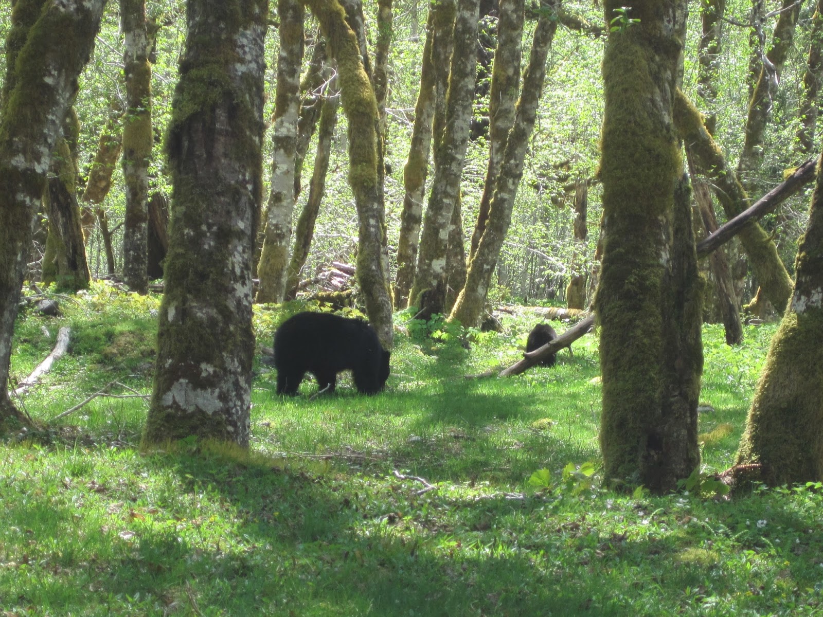 |
| Yes, I saw bears. No, I didn't get ate. |
I was giddy to be getting so close to the Enchanted Valley. After the trail dropped down into the creek bed of the Quinault, that's when I saw it -- the Chalet that was built in the 1930s. The valley opens up quickly into a wide expanse that is flanked by 5,000 feet of vertical mountains on both sides. One side is a sheer wall of waterfalls, snow chutes, and sparse trees. In the evening, mountain goats can be seen clinging to the rocky slopes.
 |
| Is this place real?! YES. |
I linger by the Chalet that had been moved back from the bank of the Quinault by the NPS because it was in danger of literally falling into the river that had changed course over the years. I pondered its history and what it must have been like to stay there back in the 1940's. Times were certainly different then. I start looking for a camp site and I find a perfect spot that is close to the river, has a view of the Range, and was under a tree. Only problem there was a bear hanging out, eating the grass under the tree. I wait patiently, admiring the towering mountains.
 |
| I wasn't going to disturb his munchings. |
In the end, I set up camp close by but not in my original desired destination because I figured I would explore the valley in the afternoon hours. I hiked about two miles further into the valley, prepared to camp wherever. As I went up into the valley, I started running into patches of snow and eventually got to a creek that I didn't want to ford. Therefore, I doubled back and by the time I returned, someone else had claimed my desired camp spot. Oh well. No complaints here! The whole area is beautiful!! :)
 |
| Enchanted Valley didn't disappoint! |
May 21st, 2017
Enchanted Valley to Pony Bridge - 11 miles
I did NOT want to leave my campsite. I unapologetic-ally admit that I was the last person that stayed overnight to leave the Chalet area. I probably departed around 12 noon. I took one, good, very long look at the valley again, and departed; retracing my steps back to the start of the trail head.
 |
| WOW! Hello! Good Morning!! |
It's not all bad, though -- going the opposite way on a trail can feel (and look!) like a completely new experience. I push all the way to Pony Bridge. Pony Bridge is a bridge over a deep gorge that has the same cloudy, turquoise water churning below. The turquoise color is from the glacial melt, way up stream. I've never really seen anything like it and I mystically stare at it for quite some time. I camp at Pony Bridge by myself. A trail runner comes running down the trail and yells "awesome camp spot!" and I think why, yes, yes it is. I even make a campfire. Believe it or not, this was the first campfire I had EVER built. Any other time, it was me enjoying a campfire someone else had already built. You better believe that I felt accomplished! Staring into a campfire... camping by yourself... there's nothing quite like it. I fall asleep in my tent with a big ol' smile on my face.
 |
| On Pony Bridge. |
May 22nd, 2017
Pony Bridge to Trailhead to Third Beach via Jeep rental to Scott's Camp - 6 miles
I wake and pack my things... a little reserved at what lies ahead for today. I know that I will reach the car in about 2.5 miles and then I will drive back to Quinault (it's an actual town). From there, I will drive to the South Coast, specifically, to Third Beach to begin that part of my backpacking.
Once I fuel myself up with town food, I begin the 1.5 hour drive up to Third Beach. I arrive in the parking lot to a woman with approximately 10 bear canisters falling out of the back of her Subaru. She tells me she is taking nine of her 7th graders on an overnight to Third Beach, about 2 miles away. I smile at her and make a mental note that I will be hiking past Third Beach even though I had intended to camp there. The trail meanders through an actual rain forest that lines the coast and then steeply declines to the beach. The trail dumps out where a creek is flowing across the beach and into the ocean. There are massive redwood trunks that have turned into beached driftwood; bleached from the sun and dried by the saltwater. I've never seen this much or this big of driftwood. It seems like everything is bigger out here... I navigate over the driftwood to the beach.
 |
| Third Beach... the beach is there, I promise! |
I hike down the beach until I see the headland. There are portions of the beach hike that aren't actually on the beach because they simply can't be. Some headlands are impassible, especially if the tide has come in. You must scale the cliffs (with ropes tied to trees, ladders, and at times, on your hands and knees) to get to the trail up top. Once on the top of the cliff, you duck back into the woods for a bit, and then drop back down (using rope, rope ladders, etc.) This type of hiking I have never done before and it's slow going. But so beautiful. It's actually very cool to see the beach from above, drop back down, go back up, and repeat. But it's tiring.
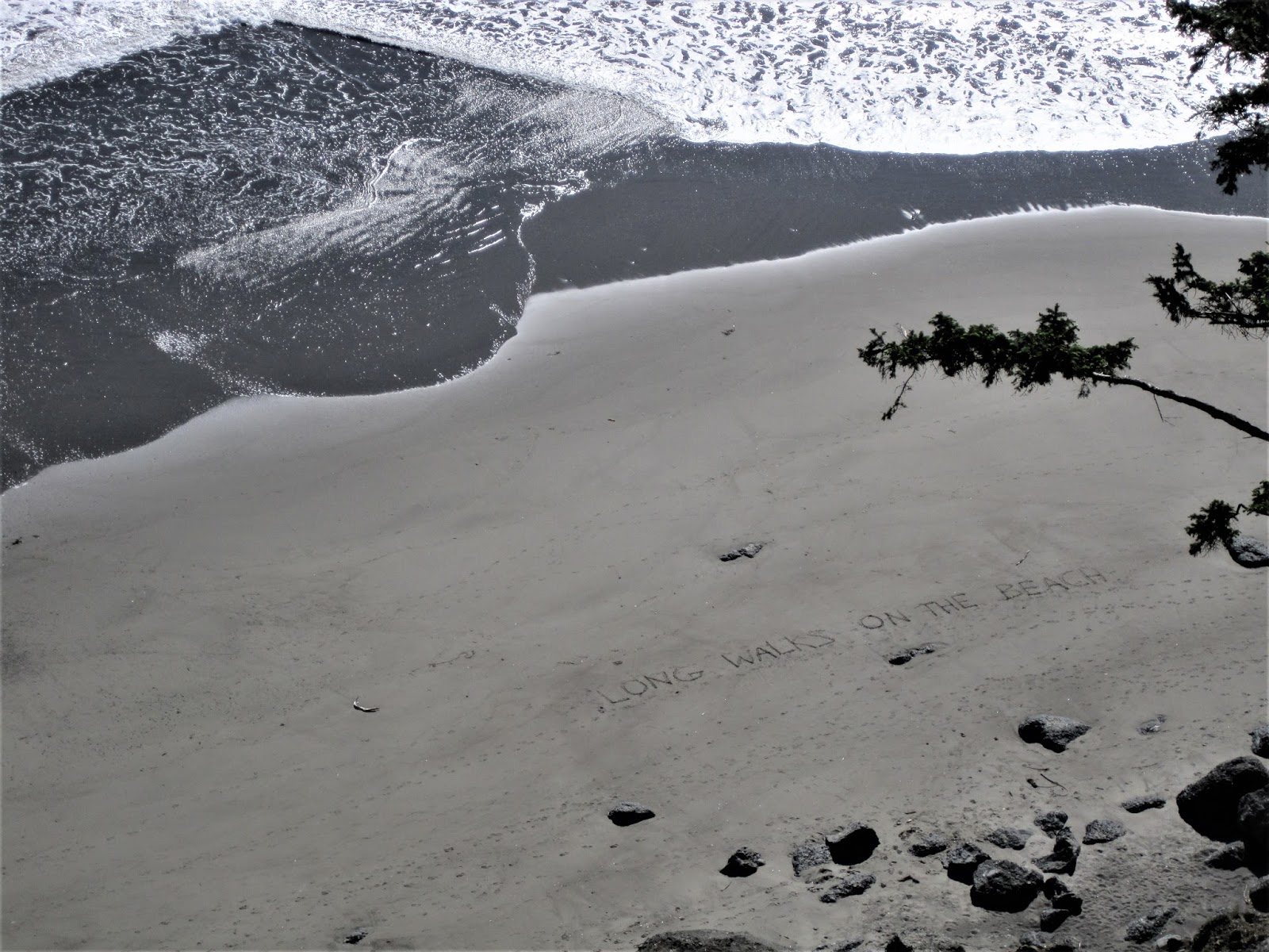 |
| I wish... (click to read message in the sand) |
I make it to Scott's Camp late in the day and when I arrive, the camp spot pickings are slim. There's about 10 adolescent boys and girls and two adults. I initially think this is a huge family vacation but I am later informed by Jason that he and his female counterpart are Wilderness Therapy Instructors that work with at risk youth. I am fascinated by this... it's an interesting concept and the first time I'd heard about it. I am even more fascinated when I learn that Jason thru hiked the AT in 2010 and the PCT in 2016. I pick his brain about the PCT while trying to not be too obnoxious.
I found a secluded camp spot just up the little embankment and well protected with about 20 feet wide of driftwood logs. I pitch my tent without the rain fly, cook dinner, and watch the Wilderness Therapy group play baseball on the beach with a tree branch for a bat and a mangled plastic ball that someone found. The sea stacks rise eerily up out of the ocean in the background and the sun is setting. Life seems to be surreal during this time. I find myself starring blankly out onto the ocean as the sun sets. I'm taking it in but, at the same time, somehow turning my mind off. It was something special. This 73-mile long stretch of coast is some of the last remaining undeveloped coastline left in the US. And here I am spending the night on it. I have no complaints.
 |
| Ahhhmazing!! :) |
May 23rd, 2017
Scott's Camp to Third Beach Trailhead - 4.5 miles
I wake to the sun poking through the clouds and a lingering heavy fog layer. In fact, it is now misting (or blowing off of the ocean). And I attempt to break camp with blowing mist and sand getting everywhere. I am essentially retracing my steps from yesterday. Before I leave camp, I look at the tide chart and I notice that the tide is about halfway to high tide. I know that if I have a chance at making it back to the car, I need to get my ass in gear. Otherwise, the tide will be too high and I will be forced to wait for it to recede again. I'm pushing hard. I'm hiking on the part of the beach adjacent to the cliff and occasionally I have to time the waves/tide when I have to round an obstacle. I make it to the headland just in time and look back. Where I was hiking has now been temporarily claimed by the tide.
I hangout at what would be almost like a lagoon that provided views out to Giant's Graveyard (the 10+ sea stacks out in the ocean). The Wilderness Therapy group is there and the kids are writing in their journals. The instructors are eating lunch and I'm talking to a couple from Austin, TX. The husband is an architect that occasionally comes to DE for work. I remark that the world is so vast yet quite small. They just nod in agreement.
 |
| Giant's Graveyard |
I descend one last time (onto Third Beach) and slowly walk the beach back to the spur trail that leads to the trailhead parking lot. This trip has been very successful and I had stellar weather. I couldn't have asked for anything better. After I arrive to the car, I drive back to Quinault and reserve a room in the Lake Quinault Lodge that was built in 1926.
May 24, 2017
Rest & Relaxation!! - 0 miles
I ate in the Roosevelt dining room and drank wine from a lawn chair that looked out on to Lake Quinault. Not too shabby a way to end this trip!
Until next time...
~Soulslosher
No comments:
Post a Comment